
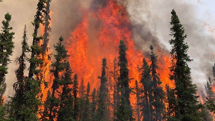
Tourism Alberta warns: Dry conditions continue in most areas of the province resulting in numerous wildfires.
Welcome to Alberta, where the bold, the adventurous, and the free-spirited come to play. This is the message on Alberta’s Travel website.
As of this afternoon, more than 24,000 individuals have been evacuated from communities throughout north and central Alberta, Canada.
Alberta is one of the thirteen provinces and territories of Canada.
It is part of Western Canada and is one of the three prairie provinces. Alberta is bordered by British Columbia to the west, Saskatchewan to the east, the Northwest Territories (NWT) to the north, and the U.S. state of Montana to the south.
It is one of the only two landlocked provinces in Canada.
Alberta hosted the Artic Winter Games, but the current situation of out-of-control wildfires is nothing compared to the ice, snow, and artic climate.
Alberta has a vibrant tourism industry, and visitors should be aware of the emergency and follow the guidelines set by Canadian authorities.
The Forest Protection Area in Alberta comprises all the polygons that represent the administrative areas established by Forest Protection, Forestry Division of Alberta Agriculture and Forestry, concerned with the prevention and control of damage to forests from fire, insects, disease, and other harmful agents.
The current situation in Alberta
As stated on the Alberta Tourism website, there are 13 wildfires of note in the Forest Protection Area of Alberta.
EWF-031
- Wildfire EWF-031 is located 14 km Southeast of Edson; Minnow Lake Provincial Recreation Area has been overrun by the wildfire. It is still classified as out of control at 77,920 hectares.
- Alberta Wildfire responds with two dozer groups, two intermediate, and one medium helicopter: one ignition helicopter and air tanker support.
WCU-001 and WCU-002
- These wildfires are located in the Evansburg/Entwistle/Wildwood/Hansonville area.
- These wildfires are classified as out of control at 8586ha (WCU001) & 2,400 ha (WCU002).
- Wildfire WCU-002 is approximately 7 km northwest of Evansburg on both sides of Highway 22, and 3 km north of Highway 16. This wildfire is classified as out of control at 2,700 hectares in size and is 65 percent contained.
- There are 80 wildland firefighters, helicopters, and heavy equipment working to control this wildfire.
- Airtankers are available if required.
- The structural protection unit is on scene and integrating operations with Yellowhead County.
- Heavy equipment worked through the night to contain the excursion on the north side of the fire. The fire also crossed established guard on the SW corner; heavy equipment contained that excursion as well.
- An evacuation order is in place for residents East of the Pembina.
HWF-030 (Fox Lake)
- Wildfire HWF-030 is in the community of Fox Lake. This wildfire is classified as out of control at 16,390 hectares.
- There are 70 firefighters, aircraft, and structure protection crews with vehicles, heavy equipment, and helicopters working on this fire. Airtankers are also supporting this wildfire.
- The community of Fox Lake has been fully evacuated to the town of High Level.
- Alberta Wildfire is actively suppressing this wildfire with the current resources.
HWF-036
- This wildfire is located near the Rainbow Lake Community. It is classified as out of control at 2,130 hectares.
- Alberta Wildfire is responding with 44 firefighters, heavy equipment, and helicopters.
- County has declared a State of Local Emergency and is on an evacuation alert to prepare residents for possible evacuation.
RCU-005
- Wildfire RCU-005 is 2 km from the south edge of Drayton Valley. It is classified as out of control at 3,500 hectares.
- Alberta Wildfire is responding with 26 wildfire fighters and helicopters to the wildfire. Airtankers will also be supporting the firefighting efforts today. Brazeau County has additional resources to assist with this wildfire.
RWF-034
- Wildfire RWF-034 is located near the O’Chiese Reserve. It is classified as out of control at 51,000 hectares.
- The Reserve has been put on evacuation alert, and several homes have been evacuated.
GWF-017
- Wildfire GWF-017 is located 3 km Southeast of Sturgeon Lake Cree Nation. It is classified as out of control at 1,600 hectares.
- There are currently road closures in the area.
GCU-003
- This wildfire is located Southwest of Grande Prairie. It is currently classified as out of control at 1,000 hectares.
- The County is leading an evacuation around the fire for a 10km radius.
- Smoke has impacted the ability to have aircraft responding to this wildfire.
GWF-018
- This wildfire is in Clearhills County. It is classified as out of control at 8,500 hectares.
- There is heavy equipment working to build a guard around this wildfire.
WWF-023
- This wildfire is located in the Fox Creek Area. It is classified as out of control at 15,000 hectares.
- There are 16 firefighters, two helicopters, and heavy equipment responding to this wildfire.
- An evacuation order was issued on May 6 for people in this area.
SWF-053/058/063 Merged together (Grizzly Complex)
- The Grizzly Complex is comprised of SWF-053, SWF-058 and SWF-063. This wildfire is still classified as out of control at 58,000 hectares.
SWF-060
- This wildfire is located in the Utikima Lake, Whitefish Lake and Gift Lake First Nation. It is classified as out of control at 10,000 hectares.
- There are 24 firefighters, five helicopters and heavy equipment responding to this wildfire.
SWF-068
- This wildfire is located in the area of the Peavine Metis Settlement. It is classified as out of control at 10,000 hectares.
- Firefighters along wi
- Alberta has declared a provincial state of emergency. Visit Alberta.ca/emergency for information or call 310-4455.
- Mandatory evacuation orders are in effect for the following areas. Please check alberta.ca/emergency or download the Alberta Emergency Alert mobile app for complete information:
- Parts of Brazeau County. Evacuees should register in Edmonton at the Expo Centre, Hall C, at 7515 118 Avenue.
- Parts of Northern Sunrise County.
- Parts of Mackenzie County. Evacuees should register at the High Level Rural Hall.
- The entire Town of Rainbow Lake. Evacuees should register in High Level at the High Level Arena, at 10101 105 Avenue.
- Fox Creek, Little Smoky and surrounding areas. Evacuees should register at the Allan and Jean Millar Centre, at 58 Sunset Boulevard in Whitecourt.
- Parts of Sturgeon Lake Cree Nation and the Municipal District of Greenview. Evacuees should register at Memorial Hall, 4808 50 Street in Valleyview.
- Parts of the County of Grande Prairie. Evacuees should register at the Bonnets Energy Centre, 10017 99 Avenue, Grande Prairie.
- Parts of Big Lakes County. Evacuees should register at Elks Rodeo Hall on Highway 749.
- Parts of Lac Ste Anne County. Evacuees should register at the Mayerthorpe Diamond Centre, at 4184 54 Street.
- Parts of Yellowhead County, including the Town of Edson.
- The communities of Whitefish River and Aitkameg. Evacuees should register at the Town of Slave Lake office, at 10 Main Street, Slave Lake.
- The Hamlet of Entwistle. Evacuees should register at Wabamun Jubilee Hall, at 5132 53 Avenue in Wabamun.
- Parkland County and the Hamlet of Entwistle. Evacuees should register at Wabamun Jubilee Hall at 5132 53 Avenue in Wabamun.
- Residents of the following areas should be prepared to evacuate on short notice:
- The Grovesdale area of the Municipal District of Greenview
- The area west of Beaverdam Provincial Recreation Area and east of the Bighorn Dam, including the hamlet of Nordegg.
- Parts of the County of Grande Prairie, including Pipestone Creek area.
- The town of High Prairie.
- Parts of Wetaskiwin County.
- Sixteen declared states of local emergency and two band council resolution include:
- Big Lakes County
- Brazeau County
- County of Grande Prairie
- Clear Hills County
- Clearwater County
- Drayton Valley
- Town of Edson
- MD of Fairview
- Town of High Prairie
- Northern Sunrise County
- East Prairie Metis Settlement
- Saddle Hills County
- Lac St. Anne County
- Parkland County
- Rainbow Lake
- Yellowhead County
- The Little Red River Cree Nation (Fox Lake) has declared a band council resolution
- Whitefish Lake First Nation has declared a band council resolution.
Alberta Police issued this information for evacuees
- Evacuees should register at the reception center identified for their community so staff can quickly assist them and connect them with the needed resources.
Fire bans and other restrictions
- Unusually warm, dry weather and strong winds mean it is easier for a wildfire to start and spread.
- As a result of these conditions, the entire province is under a fire ban. No open burning is allowed, including backyard fire pits inside the Forest Protection Area. Alberta Parks and many municipalities and communities have ordered their own bans and restrictions. For more information, visit Albertafirebans.ca.
- A provincial off-highway vehicle restriction is also in place, which means the recreational use of off-highway vehicles on public land, including on designated OHV trails, is prohibited.
Wildfire activity updates
- There are 110 active wildfires in the Forest Protection Area, 37 classified as out of control.
- Information on all wildfires is on the Alberta Wildfire dashboard and the Alberta Wildfire app.
Travel
- There are multiple road closures and advisories for north and central Alberta.
- Visit 511.alberta.ca for up-to-date information on road closures and travel advisories.
Health
- EMS and zones remain fully engaged to ensure safe transport and care of all patients/residents. Other zones and provincial programs are assisting with reception centers and ensuring the availability of spaces/equipment as needed.
- Alberta Health Services is deploying mobile air quality monitoring as multiple communities report high levels of smoke and ash residue.
- Up-to-date information about wildfires or healthcare resources visit the Alberta Health Services Wildfire Resources webpage.
- For non-emergency health advice, including information on their health care options, or call Health Link at 811.
IMEX Frankfurt May 23-25 is where the global business events community comes together for four exhilarating days every year. Where more than 3,000 meeting planners meet with 2,500-plus suppliers from every corner of the globe. This is where powerful business connections that offer real ROI are made. Whether you’re an events newbie or a pro (or anything in between), IMEX 2023 is exactly where you need to be. REGISTER FREE FOR IMEX NOW